![](/images/other/stat-length.png)
![Tocht Stappen Le Pradet - SityTrail - le Pradet les trois forts - Photo](https://media.geolcdn.com/t/1900/400/f3d5c1c4-abd6-4c30-a189-71ee7c6f2626.jpg&format=pjpeg&maxdim=2)
SityTrail - le Pradet les trois forts
affinetataille
Gebruiker GUIDE
![Lengte](/images/other/stat-length.png)
![Max. hoogte](https://static1.geolcdn.com/siteimages/upload/files/1508320355ic_sort_altitude_max_24dp.png)
![Positief hoogteverschil](https://static1.geolcdn.com/siteimages/upload/files/1508320355ic_sort_den_pos_24dp.png)
![Km-Effort](/images/other/stat-length.png)
![Min. hoogte](https://static1.geolcdn.com/siteimages/upload/files/1508320355ic_sort_altitude_min_24dp.png)
![Negatief hoogteverschil](https://static1.geolcdn.com/siteimages/upload/files/1508320355ic_sort_den_neg_24dp.png)
![Boucle](https://static1.geolcdn.com/siteimages/upload/files/16400158638029165_repeat_loop_refresh_sync_direction_icon.png)
![Stappen](https://static1.geolcdn.com/sitytour/trail-icons/101.png)
4h27
Moeilijkheid : Zeer moeilijk
![Scan deze QR-code om de tocht te openen in de SityTrail-applicatie](https://capi.geolives.com/qq0zvz2zws4bq2lad0pu/sitytour/trails/2643814/qr.png?size=200)
Gratisgps-wandelapplicatie
Over ons
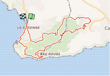
Tocht Stappen van 13,3 km beschikbaar op Provence-Alpes-Côte d'Azur, Var, Le Pradet. Deze tocht wordt voorgesteld door affinetataille.
Beschrijving
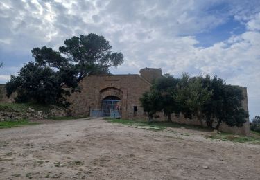
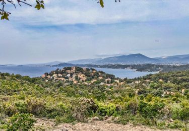
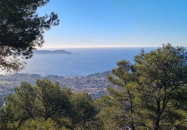
La rando du jour: Le tour des 3 forts au Pradet.
Fort de La Bayarde - Fort de La Colle Noire - Fort de La Gavaresse.
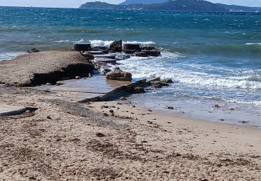
Retour par le sentier des douaniers depuis la Mine de Cap Garonne jusqu'à la plage de La Garonne.
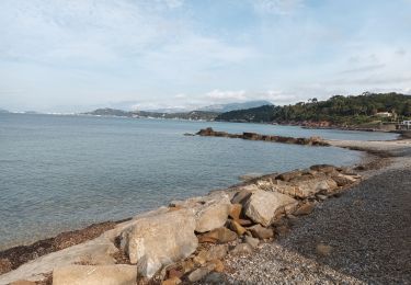
De magnifiques vues sur la presqu'ile de Giens et les Iles d'Hyères dans un premier temps, puis sur la Rade de Toulon (la plus belle de tout l'univers intergalactique) par la suite.
Passage le long des falaises du Bau Rouge pour continuer.
Retour enfin par le bord de mer entre le port des Oursinières et la plage de la Garonne.
Une magnifique journée
Plaatsbepaling
Opmerkingen
Wandeltochten in de omgeving
![Tocht Stappen La Crau - Le Paradis et le mont des oiseaux - Photo](https://media.geolcdn.com/t/375/260/3ea9709f-1bf2-4174-850e-73122825f7f5.jpg&format=jpg&maxdim=2)
![Stappen Stappen](https://static1.geolcdn.com/sitytour/trail-icons/101.png)
Stappen
![](/images/other/stat-length.png)
![](https://static1.geolcdn.com/siteimages/upload/files/16400158638029165_repeat_loop_refresh_sync_direction_icon.png)
![Tocht Te voet Le Pradet - le pradet plage de la garonne la mine - Photo](https://media.geolcdn.com/t/375/260/ext.jpg?maxdim=2&url=https%3A%2F%2Fstatic1.geolcdn.com%2Fsiteimages%2Fupload%2Ffiles%2F1545311037marcheuse_200dpi.jpg)
![Te voet Te voet](https://static1.geolcdn.com/sitytour/trail-icons/100.png)
Te voet
![](/images/other/stat-length.png)
![](https://static1.geolcdn.com/siteimages/upload/files/16400158638029165_repeat_loop_refresh_sync_direction_icon.png)
![Tocht Fiets La Garde - piste cyclable la garde almanar hyeres - Photo](https://media.geolcdn.com/t/375/260/ext.jpg?maxdim=2&url=https%3A%2F%2Fstatic1.geolcdn.com%2Fsiteimages%2Fupload%2Ffiles%2F1524743154velo.jpg)
![Fiets Fiets](https://static1.geolcdn.com/sitytour/trail-icons/200.png)
Fiets
![](/images/other/stat-length.png)
![](https://static1.geolcdn.com/siteimages/upload/files/16400158638029165_repeat_loop_refresh_sync_direction_icon.png)
![Tocht Stappen Le Pradet - les 3 forts depuis la plage de la Garonne - Photo](https://media.geolcdn.com/t/375/260/1cc1b5b0-8fc0-47a1-b418-a51de495ba7d.jpg&format=jpg&maxdim=2)
![Stappen Stappen](https://static1.geolcdn.com/sitytour/trail-icons/101.png)
Stappen
![](/images/other/stat-length.png)
![](https://static1.geolcdn.com/siteimages/upload/files/16400158638029165_repeat_loop_refresh_sync_direction_icon.png)
![Tocht Stappen Le Pradet - Mine de la Garonne 2-18-10-2024 - Photo](https://media.geolcdn.com/t/375/260/eb51cf3e-5952-413e-b535-93de1e3f672e.jpg&format=jpg&maxdim=2)
![Stappen Stappen](https://static1.geolcdn.com/sitytour/trail-icons/101.png)
Stappen
![](/images/other/stat-length.png)
![](https://static1.geolcdn.com/siteimages/upload/files/16400158638029165_repeat_loop_refresh_sync_direction_icon.png)
![Tocht Stappen Le Pradet - Les 3 forts-la Garonne-21-04-23 - Photo](https://media.geolcdn.com/t/375/260/cdf1f267-1743-49a7-b754-ec47dc9a915c.jpg&format=jpg&maxdim=2)
![Stappen Stappen](https://static1.geolcdn.com/sitytour/trail-icons/101.png)
Stappen
![](/images/other/stat-length.png)
![](https://static1.geolcdn.com/siteimages/upload/files/16400158638029165_repeat_loop_refresh_sync_direction_icon.png)
![Tocht Stappen Le Pradet - pointe du baou rouge - Photo](https://media.geolcdn.com/t/375/260/638f4642-859f-44ca-89f6-effdb663d305.jpg&format=jpg&maxdim=2)
![Stappen Stappen](https://static1.geolcdn.com/sitytour/trail-icons/101.png)
Stappen
![](/images/other/stat-length.png)
![](https://static1.geolcdn.com/siteimages/upload/files/16400158638029165_repeat_loop_refresh_sync_direction_icon.png)
![Tocht Stappen La Garde - Le Plan-la Garde-24-03-23 - Photo](https://media.geolcdn.com/t/375/260/f8e95907-594c-40df-b8ff-d6795b271dba.jpg&format=jpg&maxdim=2)
![Stappen Stappen](https://static1.geolcdn.com/sitytour/trail-icons/101.png)
Stappen
![](/images/other/stat-length.png)
![](https://static1.geolcdn.com/siteimages/upload/files/16400158638029165_repeat_loop_refresh_sync_direction_icon.png)
![Tocht Stappen Carqueiranne - la grotte du paradis - Photo](https://media.geolcdn.com/t/375/260/9486f261-69b8-4de0-9e87-579eb1d901e8.jpg&format=jpg&maxdim=2)
![Stappen Stappen](https://static1.geolcdn.com/sitytour/trail-icons/101.png)
Stappen
![](/images/other/stat-length.png)
![](https://static1.geolcdn.com/siteimages/upload/files/16400158638029165_repeat_loop_refresh_sync_direction_icon.png)